Rift Zones
 |
|---|
Introduction
Throughout geological history the plates have been wandering about the globe. Fueled by geothermal processes deep within the mantle old ocean basins close up and new oceans emerge. Each time a plate is pulled apart it stretches the lithosphere. As the stretching continues rifts can occur. The continued pressure will eventually create a rift zone, and a new ocean basin is born. These rift zones are characterized by volcanism and are inundated with transverse faults. The record of magnetic anomalies on the Atlantic Ocean floor record the direction of propagation of the rifts. The information on the bottom of the Atlantic Ocean can be reconstructed to extrapolate the sequence of events of a rifting event.
| Home | Driving Forces | Volcanism | Transverse Faults | Evidence | Rifting | References |
Driving Forces
The theory of plate tectonics describes the motions of the Earth’s many lithospheric plates. These plates are brittle pieces of lithosphere that sit and move on top of the mantle. The process is driven by convection of heat through the athenosphere. Lithospheric plates move in three motions relative to each other. Each motion creates a different type of plate boundary. The plates can either be moving toward each other (convergent boundaries), away from each other (divergent boundaries), or parallel to each other (transverse boundaries). Rift zones occur at plate boundaries where the plates are moving away from each other
 |
|---|
| This image shows the various types of plate boundaries. Image courtesy of: http://w3.salemstate.edu |
The breakup of continental crust and the creation of new oceans basin begin at a rift zones. Mantle plumes, which bring up unusually hot material from deep in the mantle, have been documented at many rifting zones, although they are not essential for rifting to occur. These hot spots, however, may help speed along the rifting process in a variety of ways.
Hot spots cause a slight bulge in the overlying lithosphere (White and McKenzie 1989). In the early 1970s J . Tuzo Wilson of the University of Toronto and Kevin C. Burke and John E. Dewey from State University New York, Albany believed that the added stress from the bulging lithosphere may cause the apex of the continental dome to rupture in a three branched pattern resulting in two active rifts and one aborted rift (Courtillor and Vink 1983). In the 1980s Robert S. White and Dan P. McKenzie of the University of Cambridge conducted research that gave further evidence indicating hot spots are influential at many rift zones. Their research suggested that the added elevation of the lithospheric dome caused by the hot spot below the lithosphere helped to split the rift zone by way of increased gravity on either side of the rift (White and McKenzie 1989).
Lithosphere at divergent boundaries is stretched as the plate is being moved in different directions from conduction. As the divergent boundary is pushed in different directions the lithosphere stretches. With continual pressure from each side the lithosphere will eventually tear. Lithosphere tears in small patches along the line of most pressure. The rips are intermittent, and remain attached in some areas. These areas are referred to as “locked zones”. Despite the name, these zones do not prevent the ultimate failure of the lithosphere that lies between them. Eventually, the rifts elongate breaking the locked zone apart (Courtillor and Vink 1983).
In addition to the thinning of the lithosphere and upper mantle caused by stretching, the stretched plate is expected to subside over time. The North Sea is an example of lithosphere that has been stretched by approximately 35 percent and has subsided, creating a basin where much sediment has accumulated.
 |
|---|
Upwelling of the lower mantle occurs under the stretched lithosphere which acts to further weaken the lithosphere (White and McKenzie 1989) The partial melting of the lower mantle creates volcanism of basaltic rock that is often rich in sodium and potassium. Basaltic lava is one of the geologic characteristics of rift zones (Burchfiel 1983).
Rifting occurs when the stretching does not stop. In some regions the continental lithosphere has been only been stretched a small amount before the stretching stops. If the stretching factor is near two, then limited upwelling that will result should cause little, if any, melting of the mantle. However, the lithosphere will still experience subsidence due to the stretching that did occur. According to seismic studies the final rupture comes once the lithosphere has been stretched beyond a factor of six (White and McKenzie 1989).
| Home | Driving Forces | Volcanism | Transverse Faults | Evidence | Rifting | References |
Volcanism

Layers many kilometers thick often result from lava flow on to the thinned continental crust just after rifting occurs. The volcanic layers, which are basaltic in composition, are found on the edges of many continental margins. These layers are known to extend for lengths up to 2000 km along the coasts of Greenland, Scotland, Norway, the USA, South America, Africa, Indian, Antarctica, and Australia (White and McKenzie 1989).
The volume of magma that is released at these rift zones can be gigantic. The layers on the east coast of Greenland cover an area 2000 kilometers long, between four and 6 kilometers thick, and between 50 to 100 kilometers wide. That results in somewhere between one and two million cubic kilometers of rock produced at a single rift zone (White and McKenzie 1989)
The mid-ocean ridge is an example of a quiet rift volcano. Over much of the mid-ocean ridge magma is upwelled at nearly the same rate as the plates are spreading. Spreading along the mid ocean ridge occurs at a rate of anywhere from one centimeter to 20 centimeters per year (Bonatti and Crane 1984).
The temperature of the mantle has been recorded to have areas of unusually hot magma. If a rift opens over an area of hot mantle more of the lower mantle will melt as a result of decompression of the upwelling material. The raised mantle temperature will create larger volumes of melted mantle to be released after the rift has opened. More melting in rift areas will also cause a quicker reaction to the rift. Cooler magma will take longer to reach the surface after a rifting event has occurred than the hotter than average magma does (White and McKenzie 1989).
| Home | Driving Forces | Volcanism | Transverse Faults | Evidence | Rifting | References |
Transverse Faults
The mid-ocean ridge is the largest known rift system on Earth. The mid-ocean ridge is not a continuous, straight line of underwater mountains. In many places it is offset laterally by a few to hundreds of kilometers. In fact, if you trace the Mid-Atlantic ridge you will find that offsets occur approximately every 50 to 100 kilometers. The smallest offsets are around 30 kilometers and can be much longer. The longer offsets usually have a trough and a ridge on each side that runs parallel to the trough. The ridges on each side are called transverse or transform ridges. The troughs and transform ridges are known as oceanic fractures zones. The zones are created from the stresses caused by the rifting process that creates new ocean basins (Bonatti and Crane 1984).
 |
|---|
| As the image above shows, the mid-ocean ridge system is composed of a series of short segments broken up by transverse faults. Image courtesy of: http://oceanexplorer.noaa.gov |
 |
|---|
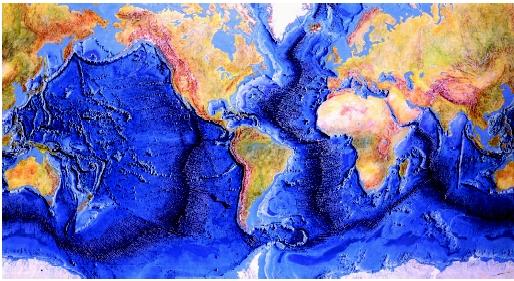
| This bathymetric map shows the extent of the mid-ocean ridge. Image courtesy of: http://oceanexplorer.noaa.gov |
| Home | Driving Forces | Volcanism | Transverse Faults | Evidence | Rifting | References |
Evidence
Magnetic anomalies locked in the rocks of the on the ocean floor provide evidence for plate tectonics and the rift zones. When new lithosphere is created the magnetic signature for the time is saved in the rocks. The varying magnetic signatures allow scientists to date the rocks according the magnetic signature of the time period. This gives scientists a way of dating the age of the ocean (Courtillot and Vink 1983). The newest ocean should be exactly at the mid-ocean ridge where new lithosphere is being created, and the oldest should be near the continents on either side of the ocean basin. The map created by the magnetic anomalies also show the path that the ocean took as it was rifting apart.
According to the magnetic anomalies, once a rift has started it propagates in a series of motions rather than in one uniform motion. The result is a jagged line that is continuous, but not linear. The transform ridges provide a temporary relief to the stresses put on a plate by the rifting process.
Magnetic anomalies on the ocean floor give evidence that rifts propagate in a nonlinear fashion. Two rifts at an angle to each other will be offset by a transform fault. When new oceanic crust is upwelled, and the center is spread, the tip of the southern rift propagates northward, transferring a block of the new ocean crust from east to west. The result is a wider ocean with a centerline that has zigzagged (Courtillor and Vink 1983).
In the Atlantic Ocean the Magnetic anomalies show that that the ocean opened up in discrete increments. According to the magnetic anomalies the South Atlantic ocean rifted first. The anomies indicate that the rift jumped from one oceanic fracture zone to the next. The rifting happened in right angles to the spreading (Courtillor and Vink 1983).
 |
|---|
| This image shows the corresponding magnetic anomalies in the oceanic lithosphere on either side of the mid-ocean ridge system. Image courtesy of: http://rst.gsfc.nasa.gov |
| Home | Driving Forces | Volcanism | Transverse Faults | Evidence | Rifting | References |
Rifting Throughout History
When Pangaea was in existence in the late Paleozoic, South American and Africa were once fused along the western side of Africa and the eastern side of South America. Australia, India, and Antarctica were once located on the eastern side of Africa. North America was located on the northern tip of South American and the northwestern tip of Africa. And northern Europe was located to the east of North America (Dalziel 1995). Each time that a continent split away from the supercontinent a rift had to form and a new ocean basin was formed. The North Sea and the Red Sea are examples of rifting zones that are still in the early stages of rifting.
 |
|---|
| Home | Driving Forces | Volcanism | Transverse Faults | Evidence | Rifting | References |
References
Bonatti, Enrico, Kathleen Crane. “Oceanic Fracture Zones.” Scientific American 250/5 (1984): 40-51
Burchfiel, B. Clark. "The Continental Crust." Scientific American 249/3(1983): 130-142.
Courtillot, Vincent, Gregory E. Vink. "How Continents Break Up." Scientific American 249/1(1983): 42-49.
Dalziel, Ian W.D.. "Earth before Pangea." Scientific American 272/1(1995): 58-63.
Gilman, Larry. "Mid-Ocean Ridges." Water Encyclopedia. 2007. 23 Apr 2008 http://www.waterencyclopedia.com/images/wsci_03_img0352.jpg
"Phytoplankton Bloom in the North Sea." Visible Earth. 21 Apr 2008. NASA. 23 Apr 2008 http://visibleearth.nasa.gov/view_rec.php?id=3136
Redfern, Martin. "Drilling into a hot volcano." BBC news 26 Mar 2006 20 Apr 2008 http://news.bbc.co.uk/1/hi/sci/tech/4846574.stm
White, Robert S., Dan P. McKenzie. "Volcanism at Rifts." Scientific American 261/1(1989): 62-71.
| Home | Driving Forces | Volcanism | Transverse Faults | Evidence | Rift Examples | References |


No comments:
Post a Comment